April 20, 2023 - Mt. Denali Sightseeing Flight in a Bush Plane
Part One

My youngest daughter Maggie and her family moved to Alaska a few months ago.  So, of course, we had to visit them in Alaska.  Lynnette and I flew up for a week.

One of my bucket list items is fly with a bush pilot out of Talkeetna Airport to see Mount Denali, highest mountain in North America at 20,310 feet.  I figured now would be a good time to do it since it wouldn't be as crowded as during the popular summer months.  Of course, the weather might be iffy this time of year.  But we lucked out with the weather; almost the entire week was good:  relatively warm in the 40s, clear blue skies and light winds.  I figured if the winds were light, the air would be smooth.  And so it was.

17 years ago, I read a book called "Wager with the Wind: a biography on the Don Sheldon, a famous Alaskan bush pilot who pioneered the technique of glacier landings on Denali (Mt. McKinley) and throughout the Alaska Range.  There are multiple air service outfits at Talkeetna but I choose Sheldon Air Services, because of the book.  It turned out to be a great choice.  I signed up for the Grand Tour plus a glacier landing.  It wasn't inexpensive, but if you're going to do it, you might as well do it right.

Maggie, Beau and I drove up to Talkeetna Thursday morning and had a delicious breakfast at the Latitude 62 restaurant.

   
Then we checked in with Sheldon Air Service around 10:30 for our 11:00 flight.  Here, our pilot, David Lee (on the right) briefs the flight.
 
David is also the owner of Sheldon Air Service.  He started flying flight tours of Denali in 1980 and has over 16,000 hours of accident free flying in the Alaska Range over a period of 38 years.  Richard, tthe big guy at left, runs the office.
   
Some Sheldon Air Service pictures on the wall.  Don Sheldon is pictured at center.   Our pilot, David Lee, married Don Sheldon's daughter Holly, but Don had died of cancer before that at the age of 53 in 1975 so David never met him.
   
A peak inside the Sheldon Air Service hangar.  Just what you might expect:  a Super Cub on skiis, a set of floats, a moose and big horn sheep heads, pelts, sleds, etc.
   

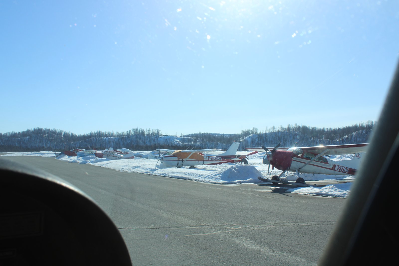
Parked outside, ready to go was our ride:  a Cessna 185  -- the best bush plane ever made, we were told.  I believe it.

The Cessna 185 Skywagon is a six-seat, single-engined, general aviation light aircraft manufactured by Cessna. It first flew as a prototype in July 1960, with the first production model completed in March 1961. The Cessna 185 is a high-winged aircraft with non-retractable conventional landing gear and a tailwheel.  The 185 has a six-cylinder, 300 hp Continental IO-520-D engine.   Over 4,400 were built with production ceasing in 1985.   This Model F version was built in 1979.


The four of us got strapped in and were soon taxiing for takeoff at Talkeetna Airport (PATK).

   
Checking out the 185's panel.  Your standard steam gauge layout.  David never even turned the handheld GPS 295 on; he probably knows the area better than the back of his hand.   The 185 has a yoke with which to fly the plane, but the co-pilots yoke has been removed.  I didn't expect David to ask me if I wanted to fly, and this just confirms I won't be doing any flying today.  David and Richard did know I built and fly an RV-7.  I mentioned during the flight that it was nice to just to be able to sit back and enjoy the flight and take pictures and not have to worry about flying the plane.
   
We're airborne!
 
Talkeetna is located at the confluence of three rivers, the Susitna, Chulitna and Talkeetna.   That's the Talkeetna River below, just after takeoff.
   

Our first glimpse of Mount Denali!  Heading north-northwest, we are headed straight for it.  Denali is 20,310 feet, but the two mountains to Denali's left are no slouches either.   Mount Foraker (17,400 feet) is 14 miles southwest of Denali and Mount Hunter (14,573 feet) is eight miles south of Denali.

As you can see, visibility is exceptional.  I estimate Denali is over 50 miles from where we are now as the Bald Eagle flies.  Not a cloud in the sky.  Winds are light.  It's not even cold, although we are all wearing our winter coats in the plane.

Talkeetna Airport field elevation is only 365 feet so we were in a slow steady climb -- 300 fpm or so -- all the way to the mountain.

   
Intricate patterns in the snow.
   
Now we're about to cross the Chulitna River I believe.
   
Now over the third, and largest river, the Susitna.
   
That's Highway 3 to the left of the river Susitna, also heading north.  Highway 3 is what we drove from Wasilla to Talkeetna.  Alaska is very big and there aren't that many highways.
   
Getting closer:  left to right:  Foraker, Hunter and Denali.  David the pilot turned the plane so we could get the money shot.
   
Looking southwest down the Chulitna River.
   
And northeast up the Chulitna River.
   
Lots of snow to the south.


Heading toward Denali again, still climbing.  We can see whispy clouds forming at the Denali summit.  David the pilot says that's an indicator of high winds.
   
Looking northeast.
   
Just beautiful.
   
Coming up on the Tokositna Glacier.
   
Like a big highway.
   
Tokositna Glacier.
   

Denali with Mt. Hunter to the left.

The Koyukon people who inhabit the area around the mountain have referred to the peak as "Denali" for centuries. In 1896, a gold prospector named it "Mount McKinley" in support of then-presidential candidate William McKinley; that name was the official name recognized by the federal government of the United States from 1917 until 2015. In August 2015, 40 years after Alaska had done so, the United States Department of the Interior announced the change of the official name of the mountain to Denali.


Maggie and Beau enjoying the flight!


I think that is Mount Huntington just to the right of Denali.
   
We've been climbing the entire flight and we're still not at 9,000 feet yet.  Yet Denali looms overhead another 10,000 feet higher!
   
Now we are headed westerly.   That might be Mount Hunter center left.
   
Another big glacier down below.  In fact, all the mountain valleys are filled with glaciers.  There are so many, not all have names.
   
Passing fairly close to a big snow covered rock.  Thankfully the air was very smooth.
   
We turn north.  I think that is Mount Foraker -- 17,400 feet -- ahead of us now.
   
Starting a gradual turn to the northeast.
   
Big Kahiltna Glacier opens up in front of us with Mount Foraker on the left.
   
We follow Tahiltna Glacier up on the southwest quandrant of Denali.
   
There's a look at Denali  to the northeast.  I think that is Mount Hunter at right.
   
We are still climbing, following the glacier up.  Peter's Pass -- 7,974 feet -- is ahead of us somewhere -- I don't see it.   But it doesn't matter because the winds are too high at the top of Denali for us to make a circle around the mountain top as originally planned.   Bummer.  But I totally agree with the pilot's decision; I know it's a very bad idea to fly around mountains with high winds.
   
We are about 9,500 feet at this point.  Denali still 10,000 feet above us!  Incredible.
   
Not sure what caused the surface of this side glacier to go squirrely.


In the middle of that glacier is the Talhiltna Base Camp, for those attempting to climb Denali, Foraker, Hunter, and more.
   
We make a 180 degree turn at the end of this cul-de-sac.
   
A better look at the Base Camp.  Climbers are dropped off by ski-equipped airplanes.  You can see where they land -- uphill -- then make a 180-degree turn and takeoff going downhill.
   
I spot a big turbo-prop Otter from one of the other air services below us.  It must have just taken off from the base camp.
   

This is as close to Denali as we're gonna get.

In 1903, James Wickersham recorded the first attempt at climbing Denali, which was unsuccessful. In 1906, Frederick Cook claimed the first ascent, but this ascent is unverified and its legitimacy questioned. The first verifiable ascent to Denali's summit was achieved on June 7, 1913, by climbers Hudson Stuck, Harry Karstens, Walter Harper, and Robert Tatum, who went by the South Summit. In 1951, Bradford Washburn pioneered the West Buttress route, considered to be the safest and easiest route, and therefore the most popular currently in use.

The mountain is regularly climbed today, by about 1,200 people a year. In 2003, around 58% of climbers reached the top. But by that time, the mountain had claimed the lives of nearly 100 mountaineers.  The vast majority of climbers use the West Buttress Route, pioneered in 1951 by Bradford Washburn, after an extensive aerial photographic analysis of the mountain. Climbers typically take two to four weeks to ascend Denali.

   
A real close-up of the Tahiltna Base Camp.  Not much down there at present.
 
During the climbing season there can be as many as 100 people at the Base Camp waiting to climb or fly out. It's quite a sight to view dozens of colorful tents all set up and occupied by people from around the World.
 
The West Buttress is the standard route climbers take to summit Denali, and it provides access to the popular, but more technical, West Rib and Cassin Ridge routes. The most popular camps along the West Buttress are located at 7,200 ft (Base Camp); 7,800 ft; 9,500 ft; 11,000 ft; 14,200 ft; and 17,200 ft. Other camps located at 12,500 ft and 16,000 ft, should only be used under ideal weather conditions as the 12,500 ft camp is vulnerable to avalanches and the 16,000 ft camp is very exposed to high winds. The 11,000 ft camp also experiences avalanches and serac fall, and care should be taken to avoid these two hazards when setting up camp. Above 14,200 ft, snow caves or igloos are usually constructed as a back up shelter in case bad weather moves in.

Total horizontal length of the West Buttress route is approximately 13 miles with about 13,500 ft of vertical gain. Between base camp and 11,000 ft, the route is relatively flat and the main hazards are crevasse falls. Above 11,000 ft, the route steepens to moderate slopes (35-45 degrees) alternating with flat benches and bowls. Equipment and supplies are typically carried by sled to 11,000 ft. Above 11,000 ft, gear and food are usually ferried between camps in two trips.

West Buttress expeditions average around 21 days. A 2-3 day supply of food and fuel should be left at base camp in case weather prevents planes from landing on the glacier (climbers have been stranded for as long as 2 weeks due to inclement weather). The following is a sample West Buttress itinerary during good weather.

Day 1: Land at Base Camp 7,200 ft.
Day 2: Rest day to organize gear and practice crevasse rescue
Day 3: Move to 7,800 ft camp
Day 4: Move to 9,500 ft camp
Day 5: Move to 11,000 ft camp
Day 6: Rest day
Day 7: Ferry loads to 14,200 ft camp, return to 11,000 ft camp
Day 8: Move to 14,200 ft camp
Day 9: Rest day
Day 10: Ferry loads to 17,200 ft camp, return to 14,200 ft
Day 11: Rest day
Day 12: Move to 17,200 ft camp
Day 13: Summit day
Day 14: Descend to 11,000 ft camp
Day 15: Descend to base camp, fly out

Denali has a reputation for streaky weather with long periods of either continuous bad weather or long periods of good weather. This explains why inexperienced climbers may reach the summit while veteran climbers don't make it back from their climb.

   
Now headed back down the Kahiltna Glacier.
   
Passing close by another big snow-covered rock.  Awesome!


Heading easterly, approaching a narrow pass.
   
Looking out my window.  Not something you see every day.
   
Now through the pass, the vista opens up.  Looking south.
   
Another plane about to pass us going the opposite direction.   All the pilots are monitoring a Unicom freq up here, letting the the other pilots know where they are and what they are doing.
   

Now about to overfly Ruth Glacier.  You can see where the glacier has carved out the side of the mountain on the left there.


Looking south at Ruth Glacier.
   
Looking north at Denali.
   
Mount Huntington.
   
Making a gradual turn to the north.


Previous
Home
Next